
It started with a dead patch of corn in my east field that I couldn’t explain.
I’d walked that field probably a dozen times, checked the irrigation lines, had the county extension agent out. Nobody could figure out why about 3 acres in the middle were just dying. Standing at the edge squinting into it felt useless — you can’t see anything useful from ground level on a problem like that.
My neighbor Dave had been talking about his agricultural drone for almost a year. I’d been half-listening, half-rolling my eyes. I’m not a tech guy. I run a 400-acre operation with my dad and brother, mostly corn and soybeans, and we’ve always done things a certain way.
But that dead patch bugged me enough that I finally called him.
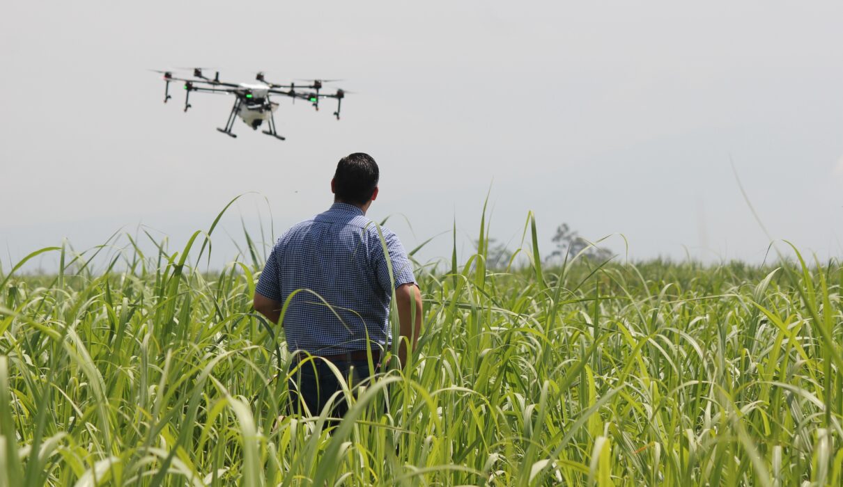
Dave came over on a Tuesday afternoon with his DJI Agras T40. We flew it over the problem area. I stood there watching it hum across the field thinking — okay, this is actually impressive. The drone pulled NDVI imagery in about 20 minutes for the whole section. Once Dave explained the color mapping, I could see it immediately — a drainage issue running diagonally under the field that nobody had caught because you’d never spot it from the ground. The dead patch made complete sense after that.
That was the moment I stopped rolling my eyes about agricultural drones entirely.
Two Weeks of Research — And My First Mistake
The first two weeks were overwhelming. I didn’t know there were this many categories. Mapping drones, spraying drones, multispectral sensor drones, drones designed for orchards versus flat row crops. At one point I had three browser tabs open comparing drones that weren’t even in the same category.
My first real mistake: I got fixated on DJI because that’s what Dave had and ignored everything else for the first week. My brother pushed me to look at the XAG P100, the Autel Dragonfish series, and some newer options from Hylio. Took me a while to figure out that the best agricultural drone depends entirely on what you’re actually trying to do.
The confusion nobody warns you about: a lot of farmers use “mapping drone” and “agricultural drone” interchangeably. They’re not the same. A mapping drone gives you data. A spraying drone lets you apply inputs. Some do both but you’re making a tradeoff somewhere.
I ended up going with a DJI Mavic 3 Multispectral first. Not a sprayer — just to get comfortable with the data side before committing to a full spraying rig. Around $5,500 with accessories. Real money for a tool I’d never used.
FAA Part 107 — Harder Than Expected
Registering with the FAA took about an hour. Fine.
Passing the Part 107 exam was not fine. Three weeks of studying in the evenings. Failed my first practice test pretty badly. I almost gave up and thought about just hiring an agricultural drone service company for the season instead. Stuck with it, passed the actual exam on my first try.
If you’re flying strictly for your own agricultural operation, there’s a recreational exception argument — but I’d still recommend getting Part 107. It protects you legally and opens more options later. A few weeks of studying in the evenings is all it takes.
First solo flight over my soybean fields: I clipped the controller signal near my grain bin and panicked and brought it down too fast. Nothing broke. I aged about five years in ten seconds.
Best Agricultural Drone Gear
Disclosure: This article may contain affiliate links. If you buy through these links, I may earn a small commission at no extra cost to you.
| Product | Best For | CTA |
|---|---|---|
| DJI Mavic 3 Multispectral | Crop scouting and NDVI mapping | Check on Amazon |
| Bwine F7MINI 4K Video 8K Photo Drones | Large-scale spraying operations | View on Amazon |
| Autel Robotics RTK Module for EVO 2 | Simpler entry into scouting | Check Price |
| Extra Smart Flight Batteries | Always carry 2-3 minimum | Buy on Amazon |
| DJI RC Pro Controller | Better outdoor screen visibility | See Deal |
| Hard Shell Drone Case | Field transport and protection | Check on Amazon |
| Portable Anemometer | Wind check before every flight | View Deal |
The Data Side — Where I Really Struggled
Here’s what nobody tells you upfront about owning an agricultural drone: the flying eventually becomes the easy part. The hard part is knowing what to do with the data.
I was generating NDVI maps and RGB orthomosaics and just looking at them. Pretty pictures. I had no workflow. No naming convention. No way to compare flights over time. By week three I had 47 GB of imagery sitting in a folder called “drone stuff” on my laptop desktop. That was mistake two — and fixing it took longer than the original flying had.
What I eventually built was simple: folders organized by field name, then date, then flight purpose. Scouting versus stand count versus end-of-season assessment. Obvious once you’ve made the mess. Not obvious before.
For processing I ended up with DJI Terra combined with QGIS for annotation. Before that I was using DroneDeploy — genuinely good software — but the subscription tier I needed for my acreage ran about $150 a month. On top of hardware cost, that felt steep. There are cheaper options but I hadn’t done the homework upfront.
What the Data Actually Showed
Once the workflow was sorted, the data started paying off in ways I hadn’t fully expected going in.
I found two areas of variable nutrient uptake across my north soybean field that I’d never have noticed walking the rows. The NDVI map showed them as distinct patches with lower reflectance values compared to the surrounding field — meaning the plants were stressed in a way that wasn’t visible yet to the naked eye. Adjusted my variable rate fertilizer application for those areas and saved somewhere around $800-$1,000 in inputs I would have blanket-applied otherwise. One season. The maps compound in value as historical data builds — next season I’ll be comparing to this season, which is something a hired agricultural drone service would never give me.
I also started using multispectral data for stand count estimates at V3 growth stage. Hadn’t expected the agricultural drone to be useful for that specifically — I’d been doing it manually with random sample plots like everyone else in the county. You walk out, count the plants in a measured section, multiply it out, hope your sample was representative. The automated counting from aerial imagery isn’t perfect — it miscounts in areas with overlapping canopy — but it’s close enough to be useful and dramatically faster than walking the field with a notebook and a hand counter.
Mistake Three — The Wind
Early June, morning flight. I was using the drone’s onboard sensors to assess conditions instead of checking a ground weather station.
About halfway through my flight plan the agricultural drone started fighting the wind hard enough that the gimbal was compensating constantly. The imagery came back blurry and completely unusable. Wasted a battery cycle and two hours of processing time on data I had to throw away.
I was irritated for the rest of that afternoon. Entirely my fault. I now check two weather apps and my own anemometer before every single flight. Check the wind. Every time. Without exception.
The Week I Questioned Everything
Late July. Three weeks of nearly solid rain. I wasn’t flying, the fields were too wet for variable rate data anyway, and I was sitting on a $5,500 agricultural drone that hadn’t left its case in weeks.
My wife pointed out — not unkindly — that we’d spent more on this drone than on her car payment for four months combined. She wasn’t wrong. I ran the math on what a hired agricultural drone service would have cost for the same scouting work. Honest answer: probably less, in year one. Definitely less, factoring in the software subscription.
But here’s where I landed. One season, maybe it doesn’t pencil out perfectly. Five seasons, it absolutely does. The data I’m building is mine. The institutional knowledge of my specific fields accumulates in a way that doesn’t reset every year when I hire a different contractor. I can compare this July’s imagery to last July’s. That comparison doesn’t exist if someone else owns the data.
And I understand my fields better now. Not just from the data itself — from the discipline of flying consistently and paying close attention at different growth stages. That forced attention has been worth something I didn’t know how to quantify before I had it.
Should You Hire Out or Buy Your Own?
A guy from my co-op asked me last month whether he should just hire an agricultural drone service instead of buying his own setup. I told him honestly: it depends on what kind of farmer you are.
If you want someone else to manage the data, handle the equipment, handle the FAA paperwork — hire it out. Good agricultural drone services exist in most regions now and they’re not as expensive as they used to be. For a one-time roof check on field issues, or a single-season assessment, the math on hiring is genuinely favorable. You’re not buying software subscriptions, not maintaining equipment, not studying for Part 107.
But if you want to actually understand what’s happening in your own fields at a level that builds over time — if you’re the kind of person who’d fly every week during the growing season just because you want to know — then owning your own agricultural drone setup makes sense. The data belongs to you. The learning belongs to you. And over several seasons, you start to know your fields in a way that no outside contractor can replicate, because they’re not there every week watching the same sections respond to the same weather patterns.
I’ve become genuinely attached to this thing in a way I didn’t expect. I’m in my shop looking at flight maps in the evening sometimes. My wife has noticed. She hasn’t said anything directly but she’s noticed.
Questions My Neighbors Keep Asking
Is it hard to learn how to fly an agricultural drone? Not as hard as I expected, honestly. The DJI hardware is forgiving in GPS-assisted mode — it holds position, it stabilizes itself, it’s designed for people who aren’t expert pilots. The harder learning curve is the data side. Understanding what NDVI values mean in your specific crop at a specific growth stage, figuring out when a stressed area is a real problem versus a temporary artifact from soil moisture variation — that takes time. Give yourself a full off-season to get comfortable with the system before you start depending on the results for real agronomic decisions.
Do you need a license to fly an agricultural drone? If you’re flying strictly for your own operation and not charging anyone for services, there’s a recreational exception argument. But I’d still recommend getting your FAA Part 107 certificate. It’s not particularly difficult — a few weeks of evening study — it protects you legally if anything goes wrong, and it opens options later if you want to help a neighbor or do any kind of commercial work. The certification also genuinely makes you a better, more careful operator.
Would you buy the same agricultural drone again? Probably not exactly the same setup. If I were starting over I’d look harder at something simpler like the Autel Evo II Pro for early scouting work before jumping straight to a multispectral sensor setup. The multispectral data is better for actual agronomic decision-making but the interpretation learning curve is steep when you’re also learning to fly and build a data workflow simultaneously. Starting simpler might have built my confidence faster and gotten me to useful results sooner.
What’s the actual ROI? Too early for a clean number. Year one felt expensive when I ran the math honestly. But I’m already seeing field patterns that will drive better input decisions over several seasons. The value of historical comparative data compounds year over year. Ask me in three years and I’ll have something real to tell you.
What the Drone Found
The dead patch in my east field turned out to be a collapsed tile from probably the 1980s — right where the drainage issue appeared in the NDVI imagery. A diagonal line of compromised drainage that had been slowly killing that section of field for decades, getting worse every wet spring, completely invisible from the surface.
We fixed it over the winter. New tile, proper drainage connection, maybe three days of work spread across November. Cost less than I expected. This spring that area looks as good as anywhere else in the field. The corn came up even, the stand count was normal, and when I flew my first agricultural drone pass over it in late May, the NDVI values matched the surrounding field for the first time.
Forty years of a problem nobody could see. Twenty minutes of flying to find it.
Still can’t quite believe that. And I probably never will entirely, even after whatever number of seasons comes next.
You Might Also Like
- Best Budget Drone — What Actually Happened When I Bought One in 2026
- I Built a $300 DIY Drone Kit Six Months Ago — Absolutely No Regrets
- Drone Car Review — My Real Experience After 8 Months (And All the Weird Stuff)
- Drone with Thermal Camera — My Real 6-Month Experience (Mistakes Included)
- How to Become a Drone Pilot — What Actually Happened When I Tried It
- Savant Home Automation Review: My Shocking Real Experience After 2 Months